Florence makes landfall near Wilmington; massive storm surge reported
Hurricane Florence came ashore as a Category 1 this morning near Wilmington, North Carolina just after 7 a.m.
Heavy flooding from the storm surge hit towns up and down the North Carolina coast overnight, as hundreds of thousands of people lost power. Emerald Isle, a barrier island town northeast of Wilmington, reported water levels 7 feet above normal just before dawn—a level that had been rising slightly even as the tide receded.
NEW: #Hurricane #Florence has made landfall near Wrightsville Beach, North Carolina at 7:15 AM EDT (1115 UTC) with estimated maximum winds of 90 mph (150 km/h), and a minimum central pressure estimate of 958 mb (28.29"). https://t.co/tW4KeGdBFb pic.twitter.com/vzpe6MjTf9
— National Hurricane Center (@NHC_Atlantic) September 14, 2018
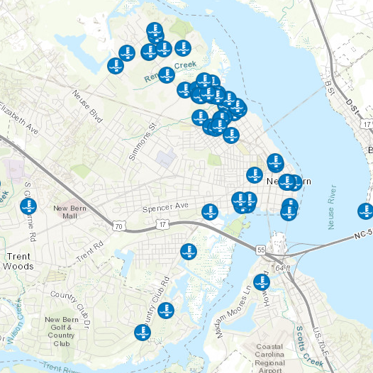
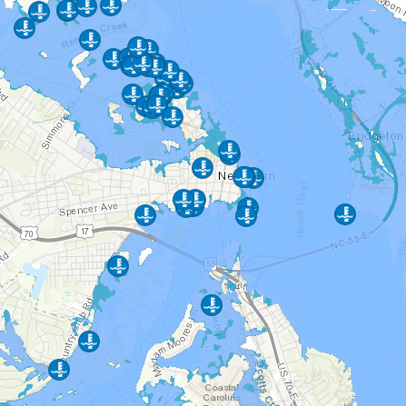
In New Bern, a town at the mouth of the Neuse River about 80 miles north of Wilmington, a map of high water calls indicated the storm surge was at or past the 100-year level—nearly 7 feet above normal around high tide early Friday morning, according to a USGS gauge. The National Hurricane Center’s color-coded storm surge prediction map tops out at 9 feet or above. The mayor said 200 water rescues had been performed.
The next high tide comes in the early afternoon, which could bring the worst flooding of the day. Even at low tide, the National Hurricane Center warned this morning, “the water levels in Pamlico Sound”—America’s biggest lagoon, which lies inside the Outer Banks—“remain elevated. These waters are expected to rise as the tides come back in.” (You can follow along with the National Hurricane Center on Twitter or check out the maps on their website.)
AdvertisementUnder normal circumstances, this afternoon might be the worst of it. But Florence is not a normal hurricane. Like Harvey, it’s a lumbering beast of a storm that crawled ashore at just 6 mph—one of those slower hurricanes that scientists have been predicting climate change would bring. That means the Atlantic Ocean is likely to stick around in local back yards, blocking roads, inundating houses, trapping residents, and poisoning fields and forests.
AdvertisementAnd then there’s the rain. As Molly Olmstead wrote in Slate yesterday,
Advertisement AdvertisementThe amount of rain Florence is expected to drop is shocking: One meteorologist put it at 10 trillion gallons over the next week in North Carolina alone. Deadly flash floods—the second leading direct cause of death from hurricanes—are essentially a guaranteed, experts warn.
The current forecast has Florence dropping between 20 and 30 inches of rain on a wide swath around Wilmington, breaking the state rainfall record and possibly the East Coast hurricane record. Some areas could receive as much as 50 inches—approaching the amounts recorded during around Houston during Harvey.
As predicted, the surge is highest at towns like New Bern, on the tributaries of the Pamlico Sound, where the storm surge rushes up estuaries and piles up against high ground. For those places, the worst is yet to come. River towns may get pinched between a surging Atlantic Ocean and swollen rivers with nowhere to drain. A record 24.5-foot surge on the Cape Fear River, for example, isn’t predicted until Tuesday. Further inland, there are many ways in which North Carolina is unprepared to handle what’s coming. Those include: low-lying communities, lax building codes, and a vast network of hog farms that have flooded the region in toxic waste during much smaller storms.
Tweet Share Share Comment本文地址:http://o.zzzogryeb.bond/html/45a799368.html
版权声明
本文仅代表作者观点,不代表本站立场。
本文系作者授权发表,未经许可,不得转载。